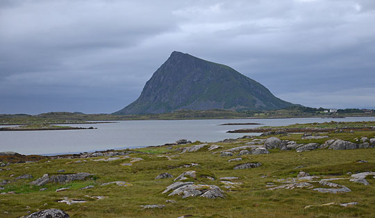
 Hordaland
A challenging mountain hike covering a total of 26.5 kilometres and 1,450 metres of elevation gain. Starting from the upper car park at Mågelitopp reduces the route to a total of 20 kilometres and the elevation gain to 1,050 metres. From the Skjeggedal car park, the first 400 metres of elevation gain are covered on the wide road leading up to the Mågelitopp car park. The onward route to Trolltunga follows stony paths that require sure-footedness. There are sections of marshy terrain, though these are limited by Norwegian standards. A very good level of fitness is essential for this long hike. As with a half-marathon, signs after every kilometre indicate how far you still have to go to reach Trolltunga. Trolltunga is accessible from mid-June to mid-September. Guided snowshoe tours are offered from mid-February to the end of May. Anyone wishing to visit Trolltunga between mid-September and the end of October should also join a guided tour. Such tours are offered by Trolltunga Active. General information about Trolltunga is available from the tourist information office in Odda.
Drive from Oslo along the E18 to Drammen and turn onto the E134 in Drammen. Drive via Hokksund, Notodden and Haukeli to Røldal. Pass Røldalsvatnet, the Røldal Ski Centre and the Røldal Tunnel. After the Trogilshol Tunnel, turn right and follow Road 13 past Skare via Odda to Tyssedal. In Tyssedal, turn right towards Trolltunga and follow the mountain road up to the Skjeggedal car park. Either park here at the pay-and-display car park (500 NOK, as of 2026) or, at the car park, turn left towards the toll booth and the barrier and drive up the bumpy track with its many hairpin bends to the Mågelitopp car park. The upper car park only has space for 30 vehicles. The barrier opens at 7:00 am; the toll is 600 NOK (as of 2026). During the high season, it is advisable to be at the barrier by 6:00 am at the latest to secure one of the sought-after parking spaces. On some days, it opens well before 7:00 am. Motorhomes and motorbikes are not permitted to use the upper car park.
From Bergen, take bus route 930 to Odda (for timetable information) or from Oslo, take the Bergen Railway to Voss and from Voss, take bus route 990 to Odda (for timetable information). From 15 June to 15 September, a shuttle bus runs from Odda to Skjeggedal. This stops at most accommodation providers in Odda (see exact departure times).
60.13286702, 6.62541937
Anzeige
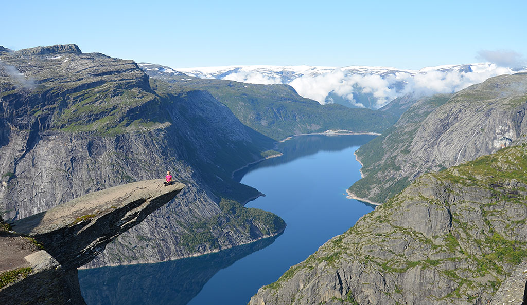
The hike to Trolltunga is one of the most popular activities in Norway. The famous photo of the rock ledge jutting out into thin air magically attracts crowds of visitors every year. Unlike the similarly spectacular Preikestolen, Trolltunga can only be reached with considerably more effort and time. From the Skjeggedal car park, the round trip covers a good 26 kilometres and 1,450 metres of elevation gain. Since 2017, thanks to the new mountain road, it has been possible to drive up from Skjeggedal to Mågelitopp, shortening the hike to 20 kilometres and 1,050 metres of elevation gain. However, the car park at Mågelitopp only has space for 30 vehicles, so you need to arrive early at the toll station to secure one of the few parking spaces.
But whichever starting point you choose, setting off early is essential. Without breaks, the hike takes a total of 9 to 10 hours. If you don’t arrive at Trolltunga until around midday or later, you may find yourself having to join a long queue to get that coveted photo. A wait of 2 or 3 hours is not uncommon during the high season. In summer, the days are long in Norway, but if you find yourself in the dark due to setting off too late and long waiting times, you can quickly get into trouble. Another option would be to spend the night in a tent so you can arrive at Trolltunga at a time when the crowds have thinned out. In any case, the route to the famous rock ledge is very scenic in itself. Once you’ve left the monotonous road behind, you find yourself in open terrain with stunning views. Standing on the Troll’s Tongue, with the yawning void beneath your feet, is ultimately the icing on the cake of this long and impressive excursion.
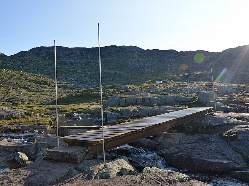
 From the car park in Skjeggedal, we walk past the toll booth and the barrier and take the road to the upper car park at Mågelitopp. We climb the wide track via numerous hairpin bends and, after an hour, reach the signposted turn-off for Trolltunga in a right-hand bend. Here we keep to the left and leave the track via a path. After just a few minutes, the ground becomes rockier and, over flat terrain, we follow the route marked with red Ts and poles through low scrub. We cross a stream using small wooden bridges and then continue our hike over flat rock. We soon leave the smooth ground behind us and, after a left-hand bend (signposted ‘Trolltunga’), the path leads us to a scree slope.
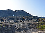
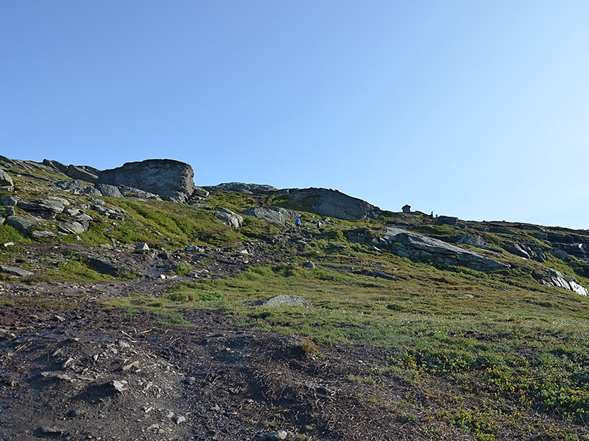
 We climb the scree slope via the path, which has been built up with many stone steps, passing small wooden huts along the way.
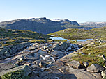
Once we have left the stony steps behind us, we step onto flat rock, over which we climb eastwards to a broad saddle. At the saddle, we are still 7 kilometres from Trolltunga. Before continuing our walk, we enjoy the view to the west towards the glaciated mountains of Folgefonna National Park. At the saddle, we ignore the signposted turn-off to Tyssevassbu on the left and walk south-east towards a lake. We pass the lake on its right (southern) side and walk past smaller lakes, heading south-east and downhill. As soon as the terrain flattens out again, we cross a stream via a wooden bridge.
We climb the scree slope via the path, which has been built up with many stone steps, passing small wooden huts along the way.
Once we have left the stony steps behind us, we step onto flat rock, over which we climb eastwards to a broad saddle. At the saddle, we are still 7 kilometres from Trolltunga. Before continuing our walk, we enjoy the view to the west towards the glaciated mountains of Folgefonna National Park. At the saddle, we ignore the signposted turn-off to Tyssevassbu on the left and walk south-east towards a lake. We pass the lake on its right (southern) side and walk past smaller lakes, heading south-east and downhill. As soon as the terrain flattens out again, we cross a stream via a wooden bridge.
 Shortly after passing the 5-kilometre sign, we reach the first of the two survival cabins. We then head towards a rocky face and climb directly up the face to a grassy ridge. We continue our hike eastwards along the moderately ascending and partly muddy path. On our right, we now look down towards Ringedalsvatnet. We pass the 4-kilometre sign and, 10 minutes later, climb more steeply up to a spur of a ridge. There, the path turns left (north-east) and we follow the trail, staying to the right of the ridge as we head uphill. About 300 metres past the 3-kilometre marker, we pass the second survival cabin, which sits perched on a hill to our left. We maintain our general direction and, a good 5 minutes later, reach a stream in a right-hand bend.
 We then climb out of the stream bed over a short stretch of more exposed terrain. Once we have left the stream bed behind us, the path curves to the left and we walk north-eastwards across marshy terrain, parts of which have been reinforced with planks. After a right-hand bend, we descend along a flat rock face past a small waterfall and, after another right-hand bend, reach a barren, moon-like landscape. We are now one kilometre from Trolltunga. We follow the red markings to a signpost. There, the path turns left (signpost ‘Trolltunga’) and leads us in a sweeping right-hand bend through the maze of boulders and small water-filled holes. A proper path is barely discernible in this lunar landscape, but the route is easy to follow thanks to the many red markings and cairns.
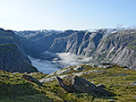
Finally, the markings guide us up a flat slope in a south-westerly direction to the cliff edge above Ringedalsvatnet. To our left, 700 metres above the abyss, hangs the Trolltunga rock ledge. From the rocky platform above the Troll’s Tongue, you climb down to Trolltunga via steps. There we enjoy a dizzying view downwards and take the obligatory photos with the turquoise Ringedalsvatnet and the snow-capped peaks of Folgefonna in the background. Those who still have the energy and inclination can follow the path from Trolltunga southwards for 20 minutes to another narrow Preikestolen above Ringedalsvatnet. It is significantly less busy here than at Trolltunga itself. Access to Preikestolen is reserved for mountaineers with absolutely no fear of heights.
Same as ascent.
No places for refreshments along the way. The two survival cabins on the route to Trolltunga may only be used for an emergency bivouac. If you wish to split the long hike over two days, your only option is to spend the night in your own tent. In the Mågelitopp area, camping is prohibited for the first 3 kilometres after the upper car park.
| Elevation | Time | Total | Destination | ||
|---|---|---|---|---|---|
| 425 m | - 810 m | + 1:00 | 1:00 | Abzweig Mågelitopp | |
| 810 m | - 1200 m | + 3:45 | 4:45 | Trolltunga | |
| 1200 m | - 810 m | + 3:45 | 8:30 | Abzweig Mågelitopp | |
| 810 m | - 425 m | + 0:45 | 9:15 | Skjeggedal | |