


 Elba
Elba 
Cable car valley station (260 m) – Romitorio di San Cerbone (530 m) – Cable car summit station (950 m) – Monte Capanne (1019 m) – Le Filicaie (870 m) – Romitorio di San Cerbone (530 m) – Marciana (380 m)
The ascent on this hike follows good, though occasionally steep, paths. Immediately after the cable car, a bit of a sense of direction is required in the lower section, as the path is somewhat overgrown. You can bypass this section by starting from Marciana, as documented in our descent report. The alternative descent route from the summit to the south-east is difficult and involves a short section secured by a wire rope (via ferrata A/B). If you wish to avoid this, take the chairlift down or use the ascent route for the descent.
From the island’s capital, Portoferraio, take the Strada Provinciale 24 towards Procchio. From there, continue on the SP25 to Marciana Marina. Leave Marciana Marina on the SP25 heading south and, shortly after Casevecchie, turn right onto the SP34. Follow the road to the car park at the cable car just before Marciana.
42.78616905, 10.16756773
Anzeige
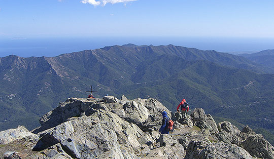
At 1,019 metres, Monte Capanne is the highest peak on Elba, and this alone makes it an attractive destination for many visitors. In the early morning hours, you can still largely enjoy the sweeping views of the sea and the mountains on your own. From 10:00 am onwards, it gets a little busier as the rather adventurous-looking cable car, with its bright yellow cabins, transports the first tourists to the summit. The ascent on foot takes you past chestnut trees and the Romitorio di San Cerbone hermitage, continuing up the north-eastern flank to the panoramic summit. For the descent, we chose the south-eastern flank, which requires sure-footedness and a head for heights. In Marciana, a picturesque mountain village, you can round off the day beautifully once the work is done.
 From the car park, we start off heading south past the valley station and after just a few metres reach a small road where there are further parking spaces. If you follow the road to the right and then immediately keep left, you reach the more comfortable but longer path, which we will use for the descent this afternoon. Today, however, we choose the slightly more adventurous route, which leads into the forest to the right of the cable car track via a few steps. Initially quite distinct, the path becomes overgrown as we gain height, and at times you have to look around a little to spot the footpath past the fallen trees. Eventually, after a climb of about 100 metres heading south, we reach the main path at a small ruin, where it ascends from the right from Marciana.
 We keep to the left on the path and climb a little further before the terrain levels out considerably again. Following a wall, we cross the cable car route heading east. The gondolas are still at a standstill; it is not until 10 am that the first guests will float towards the summit. A few metres past the cable car, the wide path reaches the Romitorio di San Cerbone hermitage, surrounded by chestnut trees. The origins of the buildings date back to the 6th century, when San Cerbone hid here whilst fleeing the Lombards. The place of worship is considered the oldest on Elba and also served as a monastery for a time. Through a small window, we can catch a glimpse of the simple interior of the otherwise locked church.
 Behind the buildings, Trail 101 continues towards Monte Capanne. We veer slightly to the right off the wide road and climb along a path through the forest for about 20 minutes until it gradually thins out. To the north-east, we can enjoy a lovely view of Poggio and the Gulf of Pocchio beyond. We cross the Grande Traversata Elba (GTE) long-distance hiking trail and, looking over the scrub to the north-west, can make out Marciana and the summit of Monte Giove to the left above it. At an old caprile, which served as a shelter for shepherds, we meet the GTE again.
 The spot is ideal for a short rest. The rocks in the immediate vicinity have already been warmed slightly by the morning sun and we enjoy the view. After setting off again, we turn right and, a few minutes later, keep to the right once more to continue our ascent along path 101 towards Monte Capanne. To our left, the jagged ridge of Le Calanche comes into view. We leave the rocky pre-summit, Monte Corto, to our right and can soon make out the small café that marks the nearby cable car summit station. A little later, the antenna masts positioned on the summit of Monte Capanne also come into view.
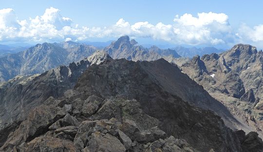
 It is still quite peaceful on the viewing terraces by the cable car. The little café is also still closed. Heading south-west, we follow a few steps, beyond which we reach the summit within minutes. The antenna masts look huge from up there, but the view of Elba’s mountains and the sea far below us is also magnificent. To the west, the rocky ridge stretches on towards Monte Cote; to the south-west, we can make out Pomonte on the coast. We enjoy the view for a good half an hour until the cable car finally starts up and we prepare for the descent to the east.
 Soon, a sign alerts us to the difficulties that Route 100 holds in store for us. With a rating of EEA, the route is recommended only for experienced mountaineers with the appropriate equipment. Well, we soon come across a short section secured by wire rope, leading over sloping terrain to the saddle. In our opinion, the difficulties do not go beyond what we would consider comparable A/B via ferrata terrain, though this is by no means a reason to ignore the trail maintainers’ advice. In any case, we reach the saddle a few minutes later and keep to the left for the descent.
 Shortly afterwards, we turn left again and now traverse largely flat terrain across the north-eastern slopes of Monte Capanne. After a good 20 minutes, we have rejoined our ascent route. We now follow this downhill, past the Romitorio di San Cerbone hermitage, towards Marciana. As we also want to pay a visit to the picturesque mountain village, we stay on the path and ignore the direct descent to the cable car. We easily reach the houses of Marciana and stroll through the narrow streets to the centre, where we round off the day in one of the restaurants. The route back to the car park takes us south, where we keep to the left at the edge of the village and follow the road to the cable car valley station.
No places for refreshments along the way. There are places to stop for a bite to eat at both the valley and summit stations of the cable car. Marciana also has a variety of restaurants.
| Elevation | Time | Total | Destination | ||
|---|---|---|---|---|---|
| 260 m | - 530 m | + 0:35 | 0:35 | Romitorio di San Cerbone | |
| 530 m | - 950 m | + 1:15 | 1:50 | Seilbahngipfelstation | |
| 950 m | - 1019 m | + 0:10 | 2:00 | Monte Capanne | |
| 1019 m | - 870 m | + 0:30 | 2:30 | Le Filicaie | |
| 870 m | - 530 m | + 1:00 | 3:30 | Romitorio di San Cerbone | |
| 530 m | - 380 m | + 0:45 | 4:15 | Marciana | |