

 Berchtesgaden Alps
Wimbach Bridge (634 m) - Watzmannhaus (1930 m) - Hocheck (2651 m) - Watzmann Middle Peak (2713 m) - Watzmann South Peak (2712 m) - Wimbachgries Hut (1327 m) - Wimbach Bridge (634 m)
Very long, strenuous and demanding mountain tour. Steep ascent to the Hocheck with short, easy and secured climbing sections. On the Watzmann ridge, secured, moderately difficult via ferrata sections (B), easy unsecured, exposed climbing sections (I) and exposed walking terrain. The descent from the south peak to Wimbachgries is very steep, strenuous and prone to rockfall. A complete lack of vertigo, sure-footedness and good physical condition are essential. Dangerous in thunderstorms, fog, wet conditions or when icy.
Rockfall helmet, via ferrata equipment
Motorway Munich – Salzburg, exit at Bad Reichenhall, continue towards Berchtesgaden; before Berchtesgaden, take the bypass towards Ramsau, via Engedey to the hiking car park at the Wimbach Bridge (parking fee €7 per day).
Take the train from Freilassing (Munich–Salzburg line) to Berchtesgaden. From the main station, take bus route 846 to the Wimbachbrücke stop in Ramsau bei Berchtesgaden (timetable and booking). The stop is right at the starting point.
47.60283140, 12.92476270
Anzeige
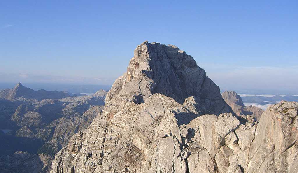
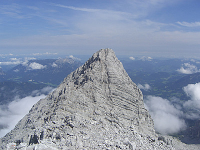
The Watzmann traverse is arguably one of the supreme challenges in the Alps. Although the Watzmann ridge presents only technical difficulties ranging from easy to moderate, However, the exposed nature of the unsecured climbing sections, the exposed walking terrain, the length of the route and the seemingly endless and arduous descent from the Südspitze (south peak) down to the Wimbachgries make this a demanding mountain tour. In the event of a risk of thunderstorms, the ridge must be avoided at all costs due to the lack of escape routes.
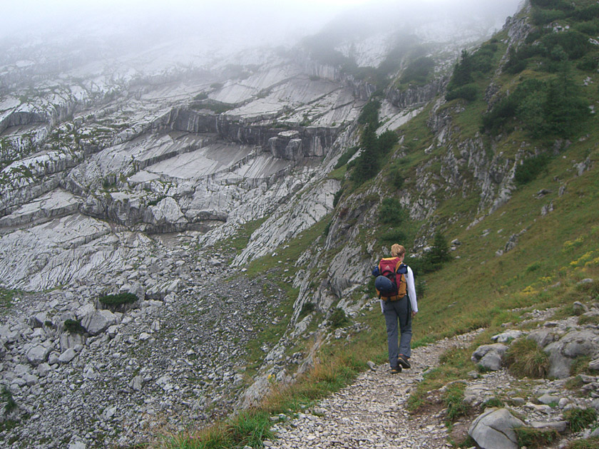 We leave the car park at the Wimbach Bridge and follow the signpost towards the Watzmannhaus. We quickly gain the first few metres of altitude via a wide and steep forest track. The path mostly winds through mountain forest before we reach the Mitterkaseralm and open terrain for the first time. From here, we have our first beautiful view of the surrounding mountains. Shortly after the alpine pasture, we head back into the forest. We reach the valley station of the material cable car leading to the Watzmannhaus. From here, the wide track gives way to a footpath. The route now climbs steeply and we soon spot the Watzmannhaus, which we reach after 3¼ hours’ walking.
 From the hut, we walk back to the junction that takes us towards the Hocheck. The terrain quickly becomes more rugged and we soon find ourselves on rocky ground. The path now winds its way up the steep slope of the Hocheck in a series of switchbacks. We reach the first easy climbing section, which is secured with a wire rope. The route now continues rapidly uphill over rocky outcrops before the terrain levels off slightly again. Soon we can also make out the supposed summit. During the ascent, we are accompanied by a magnificent view down towards the Watzmannhaus and the valley below. After a two-hour walk, we stand on the Hocheck and catch our first glimpse of the rugged Mittelspitze. The bivouac, located directly on the summit, was completely renovated in 2007.
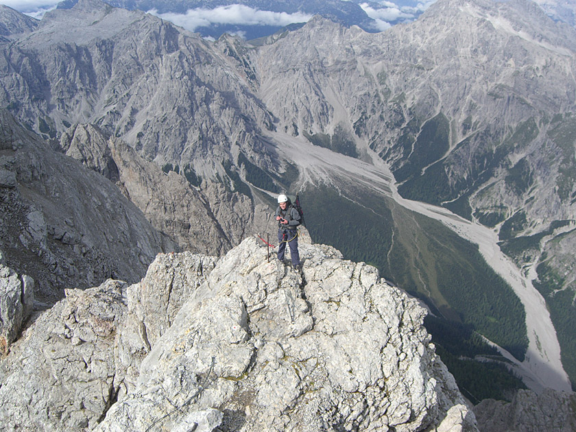
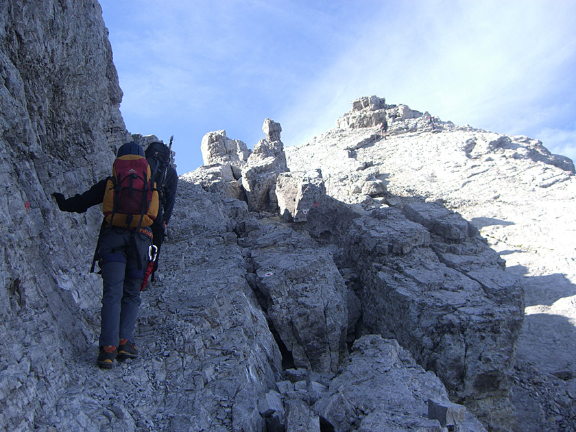 We cross a short wooden bridge from the Hocheck onto the Watzmann ridge. We are now moving directly along the exposed ridge; this section is made easier by wire ropes (A/B). We switch to the right-hand side of the ridge and descend a few metres, partly secured by wire ropes (A). The anchors become sparse, and the route is now somewhat exposed as we head towards the Mittelspitze. We ascend via a wide and steep ramp (secured, A). Beyond the ramp, we descend briefly before reaching the Mittelspitze after three quarters of an hour via a final climbing section (B). The space around the summit cross is limited, and there are hardly any places to rest. The Südspitze comes into view for the first time.
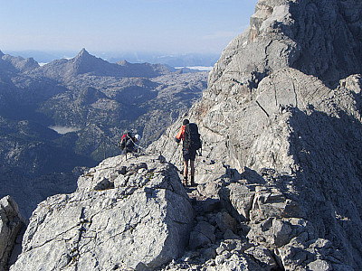
 We leave the Mittelspitze, descend a few metres and reach a gully (B), which we climb down. After this proper climbing section, the route continues downhill via further wire rope passages (first A/B, then B). After a short stretch of walking terrain, the descent continues directly along the ridge (B, exposed). The first close-up and deep views of the mighty east face are fascinating. We lose altitude once more over an almost vertical passage (B) before the terrain gradually flattens out again. On a counter-ascent, we climb a few metres up a ledge on the west side of the ridge before subsequently losing the altitude we have regained.
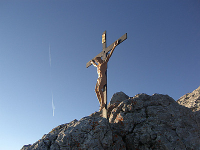
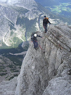
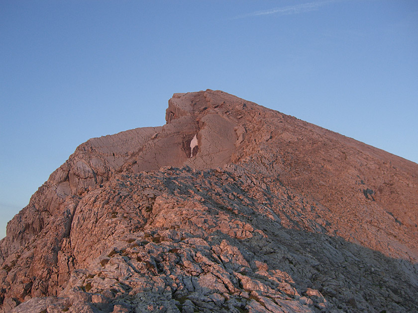
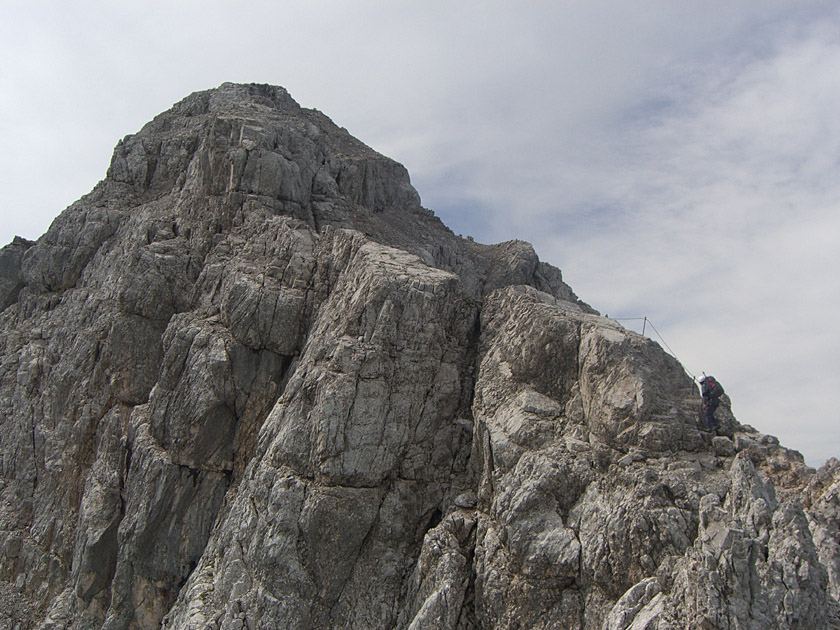 Directly on the ridge, we now head uphill again, secured by wire ropes (A), before having to descend one last time. On the west side, we now hike back up over easy terrain. We reach the ridge and walk along it for a short distance (unsecured, very exposed) before switching to the east side of the ridge (also unsecured, exposed). Once we reach the summit area, we tackle a steep section of the ridge by climbing (secured by wire ropes, B) and switch back to the west side. Over easy terrain, we come to another climbing section. This is followed by a short, exposed traverse and a final wire rope passage (A/B), over which we reach the summit cross after a final short walk.
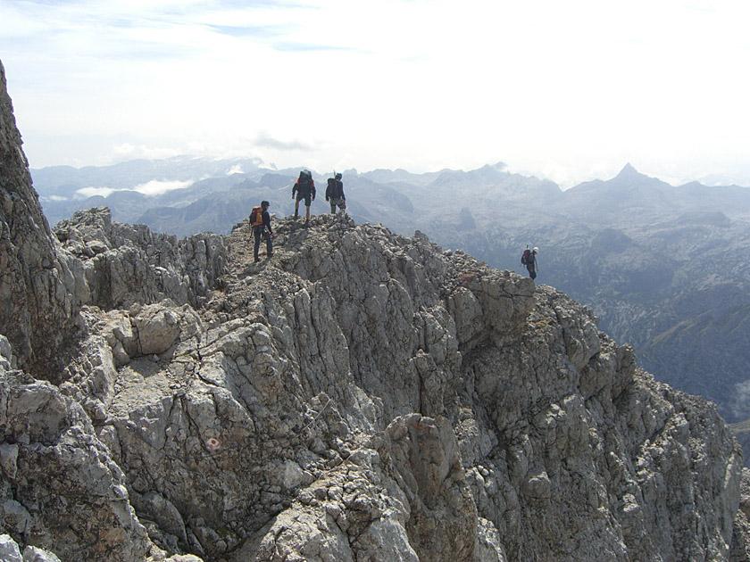 Unlike the Mittelspitze, the Südspitze offers plenty of space to rest, look around and linger. To the south, we look out from the Hochkönig across the Steinerne Meer to the Großer Hundstod. All around, the Berchtesgaden Alps, such as the Untersberg, the Hohe Göll and the Hochkalter, line up. The distant views extend as far as the glaciated peaks of the Hohe Tauern. To take your fill of this panorama, you should allow plenty of time.
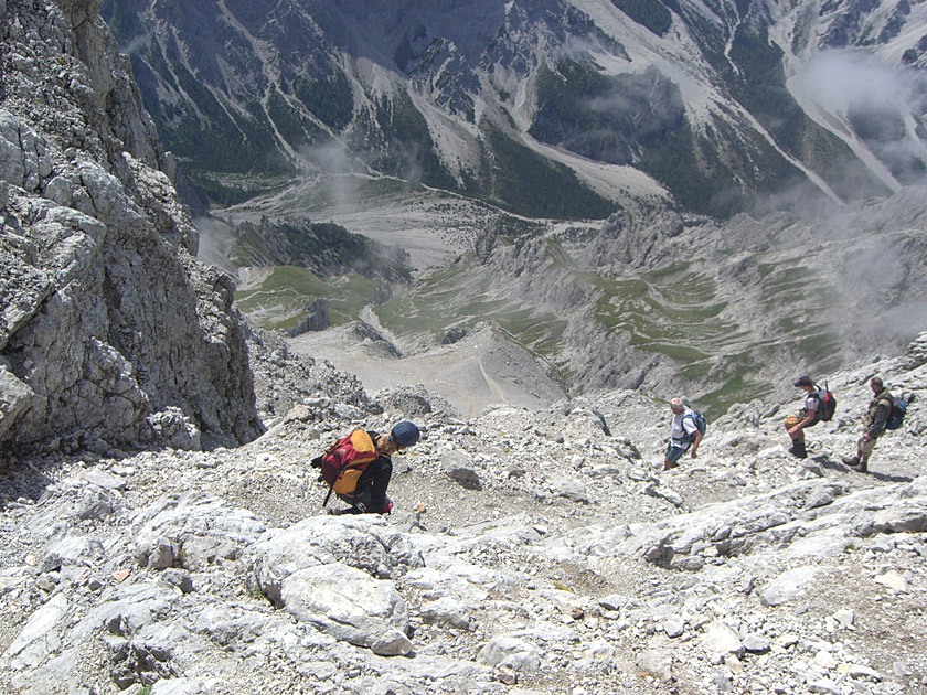 From the Südspitze, we first descend over rocky scree, partly walking, partly scrambling. The terrain offers no respite; the descent is very steep. We reach a flatter scree section. At the end of this, we continue downhill over rocky outcrops (Grade I). After just under two hours, we reach another flatter, grassy area. Beyond this lies the final descent into the Wimbachgries. The steepest and most slippery sections here are secured with chains. Three hours after leaving the south peak, we reach the Wimbachgries. Here we turn right. We are now just under three quarters of an hour away from the Wimbachgries Hut.
The return journey from the Wimbachgries Hut to the Wimbach Bridge takes a while. In two hours, we hike from the hut through the Wimbachgries between the Hochkalter and Watzmann massifs back to our starting point.
| Elevation | Time | Total | Destination | ||
|---|---|---|---|---|---|
| 634 m | - 1930 m | + 3:15 | 3:15 | Watzmannhaus | |
| 1930 m | - 2651 m | + 2:00 | 5:15 | Hocheck | |
| 2651 m | - 2713 m | + 0:45 | 6:00 | Mittelspitze | |
| 2713 m | - 2712 m | + 2:00 | 8:00 | Südspitze | |
| 2712 m | - 1327 m | + 3:45 | 11:45 | Wimbachgrieshütte | |
| 1327 m | - 634 m | + 2:00 | 13:45 | Wimbachbrücke | |


