


 Berchtesgaden Alps
Car park P4 Hintersee (780 m) – Car park P1 Seeklause (790 m) – Schärtenalm (1362 m) – Blaueishütte (1680 m) – Schöner Fleck (2029 m) – Hochkalter (2607 m)
An overall challenging alpine hike. The first day involves a moderately difficult mountain hike. The second day requires sure-footedness and a head for heights. Climbing sections rated Grade 1 and 2 on the UIAA scale must be tackled unsecured. The tour should only be attempted in stable weather conditions.
Leave the A8 Munich/Salzburg motorway at junction 115 near Piding and continue on the B21 via Bad Reichenhall and Baumgarten to Unterjettenberg. There, turn left onto the B305. After 6.3 km, turn right onto Alte Reichenhaller Str. and, just under 3 km later, turn right onto Triebenbachstraße. Follow the road to the Hintersee car park on the western shore of Lake Hintersee and park there in the pay-and-display car park.
Take the train to Berchtesgaden. From Berchtesgaden station, continue by bus 846 to the terminus at Hintersee, Ramsau b. Berchtesgaden (timetable and booking).
47.60436868, 12.84951234
Anzeige
The Hochkalter traverse is undoubtedly one of the highlights of the Berchtesgaden Alps. The tour features a stop at the Schärtenalm, an overnight stay in the rustic Blaueishütte – which is also very popular with climbers – and spectacular views, whilst also passing, at least for now, the northernmost glacier in the Alps. However, this high-alpine mountain tour should by no means be underestimated! From below the Schöner Fleck and continuing along the ridge to the summit, there are climbing sections up to lower grade 2 according to the UIAA to be mastered. The descent through the Ofental is also far from straightforward, at least in the upper section. In addition to finding the route, many find the steep, partly exposed and, above all, scree-covered terrain challenging.
 Starting from the spacious car park at the south-western tip of Hintersee, we walk along the flat shore towards the east. We soon come to Hinterseer Straße, which we follow for a short distance to the left, heading north-east. After about 400 metres, we keep to the right and begin the actual ascent at the Seeklause car park (P1). First, we follow a wide track south-eastwards, before the ascent to the Hochkalter branches off sharply to the left after about 100 metres. The Blaueishütte is also signposted here as a 2½-hour walk. We follow the well-maintained path unspectacularly to the rustic Schärtenalm, from where one can enjoy a rather lovely view of the Reiter Alpe and the Lattengebirge to the north.
 The path continues comfortably beyond the alpine hut. We are treated to a wonderful view of the east faces of the Schärtenwandkopf and the Reiteralpe to its right. Just before the valley station of the material lift to the Blaueishütte, a small path branches off to the left. Now gaining altitude much more rapidly, we continue our ascent along the western flank of the Steinberg. It takes us just under half an hour from the junction to reach the Blaueishütte.
 Early the next morning, we set off on the significantly more challenging second part of our Hochkalter traverse. Initially quite flat, we walk along the path behind the hut, between the mountain pines and rocks, towards the Blaueis Glacier. To the left, the path branches off towards the Steinberg and later the Schärtenspitze. Only at a rock marked with the red letters ‘H. K.’ for Hochkalter do we keep to the right. A short distance behind us here lie the remains of the old Blaueis Hut, destroyed by an avalanche in 1955.
reach the summit meadow and climb, keeping to the left, up to the wrought-iron cross on the Fockenstein (1,564 m).
Early the next morning, we set off on the significantly more challenging second part of our Hochkalter traverse. Initially quite flat, we walk along the path behind the hut, between the mountain pines and rocks, towards the Blaueis Glacier. To the left, the path branches off towards the Steinberg and later the Schärtenspitze. Only at a rock marked with the red letters ‘H. K.’ for Hochkalter do we keep to the right. A short distance behind us here lie the remains of the old Blaueis Hut, destroyed by an avalanche in 1955.
reach the summit meadow and climb, keeping to the left, up to the wrought-iron cross on the Fockenstein (1,564 m).
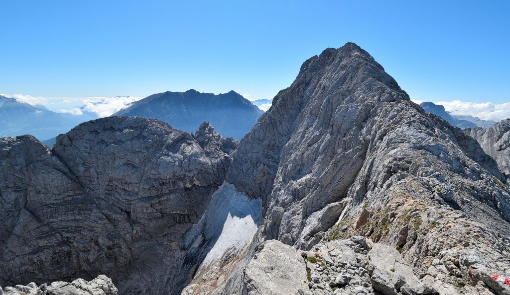
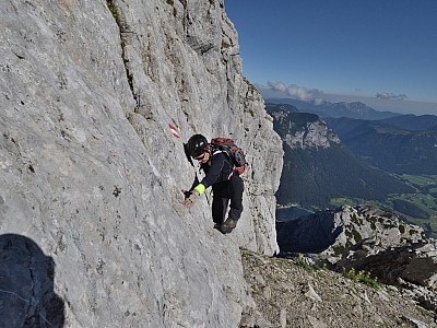
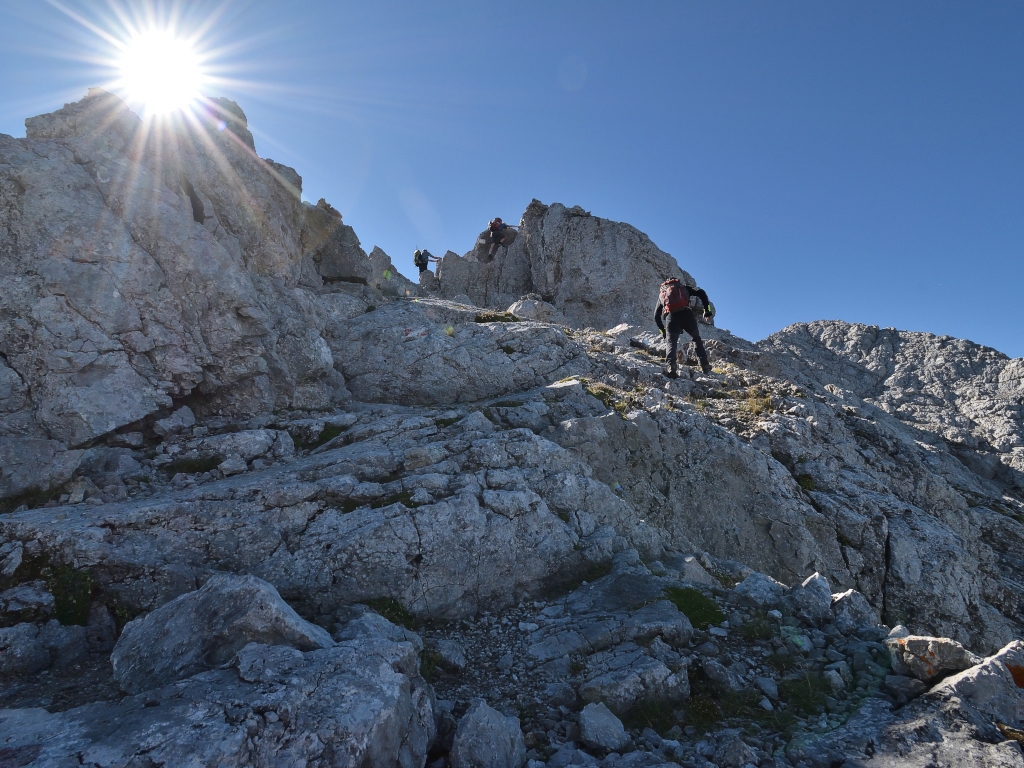
 Heading directly west, we now make our way towards a gully that becomes increasingly scree-covered and steep. We gain altitude rapidly here via numerous switchbacks. To our left, we can see climbers confidently scaling the steep slopes of the Rotpalfen. Shortly before the “Schöner Fleck” saddle, the climbing begins for us too, albeit considerably easier. Well marked, we make our way along the route through the wall interspersed with mountain pines. The dry rock provides good grip, though this should not obscure the fact that sections of climbing at lower II on the UIAA scale must be negotiated here. About an hour after setting off from the hut, we reach the ridge and thus the “Schöner Fleck” saddle.
 Once at the top, we keep to the left. Initially quite exposed, later steeper but less exposed, the path now leads us towards the Rotpalfen. Time and again, we have to negotiate small steps, though these remain at Grade I difficulty. Before we bypass the Rotpalfen a little to the west, we climb a wall about 10 metres high. Once again excellently marked, the route on the Grade II ridge presents no difficulties.

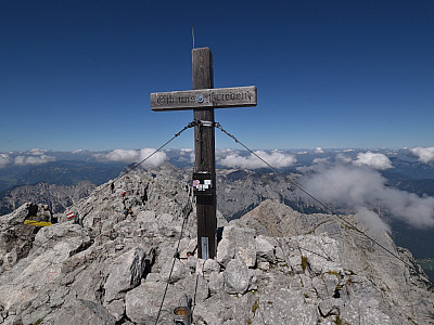
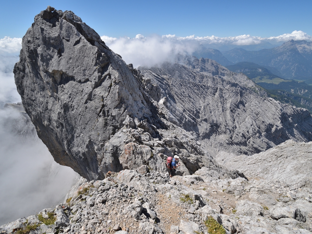
 The path through boulder fields and steps does not get any more difficult from here. We enjoy the fantastic view of the Blaueisspitze and the Blaueis Glacier below. The Watzmann also reveals itself behind it in all its glory, albeit from a rather unusual perspective. We pass the summit of the Kleinkalter almost in passing and sometimes imagine ourselves already closer to the actual summit. But eventually, the mighty summit cross appears at the end of the ridge. One last saddle and a bit of scrambling, then we stand on the panoramic summit of the Hochkalter.

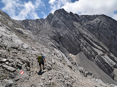
 The descent takes us south of the summit into the Ofental. Passing a huge rock that leans precariously towards the Wimbachtal, the path leads us into the Ofental. The descent is steep and unpleasantly stony. The path turns left towards the Ofentalscharte. Constantly searching for the markings, which are naturally harder to find in the loose rock, we quickly lose altitude.
At the saddle, the smooth walls of the “Schöne Wand” are impressive, stretching eastwards into the Schneelahngraben. Our descent continues on the western side of the saddle and requires continued concentration until we reach the extensive scree fields of the Ofental valley.
The descent takes us south of the summit into the Ofental. Passing a huge rock that leans precariously towards the Wimbachtal, the path leads us into the Ofental. The descent is steep and unpleasantly stony. The path turns left towards the Ofentalscharte. Constantly searching for the markings, which are naturally harder to find in the loose rock, we quickly lose altitude.
At the saddle, the smooth walls of the “Schöne Wand” are impressive, stretching eastwards into the Schneelahngraben. Our descent continues on the western side of the saddle and requires continued concentration until we reach the extensive scree fields of the Ofental valley.
 Now considerably easier, the path leads us north-west towards the Reiter Alpe. To the right and left, mighty rock faces tower up and at first there is no greenery to be seen. It is only from around 1,600 metres that we encounter vegetation again. Passing larch and mountain pine, the path winds its way down into the valley. The forest becomes increasingly dense and from around 1,000 metres we can continue our descent comfortably along a track. After reaching the Klausbach in the valley, we keep to the right. Passing two huge and beautiful wooden bird heads, we pass the Berchtesgaden National Park information centre. Had we not stopped for a break shortly afterwards, we would have reached the car park at Hintersee a little later.
Schärtenalm (1359 m), Tel. +49 8657 983585. Open from late May to early October.
Blaueishütte (1680 m), DAV Berchtesgaden, Tel. +49 (0)8657 / 271. Open from mid-May to early October.
| Elevation | Time | Total | Destination | ||
|---|---|---|---|---|---|
| 780 m | - 790 m | + 0:15 | 0:15 | Parkplatz P1 Seeklause | |
| 790 m | - 1362 m | + 1:15 | 1:30 | Schärtenalm | |
| 1362 m | - 1680 m | + 0:45 | 2:15 | Blaueishütte | |
| 1680 m | - 2029 m | + 1:00 | 3:15 | Schöner Fleck | |
| 2029 m | - 2607 m | + 2:00 | 5:15 | Hochkalter | |
| 2607 m | - 780 m | + 4:30 | 9:45 | Parkplatz P4 Hintersee | |


