 Bergamo Alps
Car park at Rifugio Roccoli Lorla (1,450 m) – Rifugio Roccoli Lorla (1,463 m) – Ca' da Legn (2,148 m) – Monte Legnone (2,610 m)
Challenging mountain hike with short sections secured by wire ropes and a short climbing section near the summit. Sure-footedness, a head for heights and good physical fitness are required. Highest mountain on Lake Como.
From the north via Colico, from the south via Lecco and Belláno to Dervio. In the centre of Dervio, turn off into the Valle Varron. Continue along a partly narrow road via Introzzo to Treménico. At the start of the village, turn left towards Rifugio Roccoli Lorla and drive up the even narrower tarmac road to the refuge car park.
46.09609747, 9.36552773
Anzeige
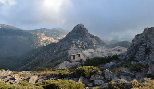
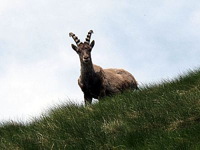
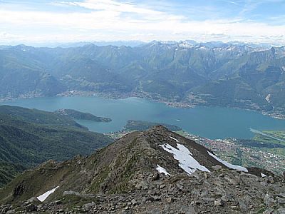
No matter from which angle you view the northern part of Lake Como, Monte Legnone dominates the panorama. This striking rocky formation, which also marks the highest point on Lake Como, magically draws all eyes to itself, both on water and on land. The ascent of Monte Legnone proves less difficult than its forbidding appearance might suggest. For the long climb from Rifugio Roccoli Lorla, you should be in good physical condition and sure-footed for the few climbing sections. With a bit of luck, you may spot marmots and ibex during the ascent.
 We begin the hike to Monte Legnone at the car park of the Rifugio Roccoli Lorla and walk past the refuge, which is tucked away on a hill in the woods on the left-hand side. Following a varied path, we first walk through sparse coniferous forest before we gradually start to gain altitude. Soon we catch our first glimpses of Lake Como. After a good hour, we emerge from a wooded area and descend into a saddle where the Alpe Argono mountain hut is situated. Those who wish can buy cheese at the hut.
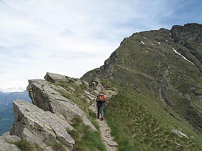
 Having left the hut to our right, we pass another barn half an hour later. After the stone building, the path steepens considerably and we climb in steep switchbacks up the grassy flank to the small pre-summit of Porta dei Merli. Over a connecting ridge, we now follow a rocky path – partly secured with ropes – with gentle ups and downs to the shelter at Ca’ da Legn. It’s worth pausing here briefly to enjoy the fantastic panoramic view before tackling the steep final push. To the south-west, we can make out Lake Lugano, which until now had been hidden behind the rocky peaks of the Adula Alps.
 After the bivouac, we now head towards the summit ridge. We tackle a short climbing section secured by a rope. Mostly to the right of the ridge and only rarely on the ridge itself, the path now winds steeply uphill in countless switchbacks. At a large cairn, we cross from the ridge over to a scree gully. Beside the gully, we now climb over scree to just below the secondary summit of the Anticima. The summit, marked by a signpost, can be reached either via a short, rope-secured climbing section or simply by bypassing it to the left and hiking up the rear side without any scrambling.
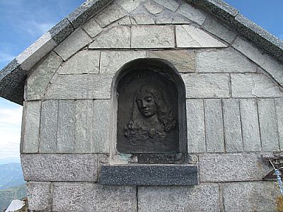
 From the secondary summit, the route follows the ridge – partly secured by ropes – across to the summit structure. After a final climbing section, we reach the large summit cross and the summit Madonna. At the summit, the view now sweeps out in a seemingly endless panorama over the glaciated peaks of Gran Paradiso and the Valais Alps, across the Adula Alps, the Platta Group, the Bernina Group and the Bergamo Alps, as well as the waters of Lake Como and Lake Lugano with their gentler and more charming peaks to the south.
Same as ascent.
Rifugio Roccoli Lorla (1463 m), Tel. +39 0341/875014. Open daily from mid-June to the end of August, and at weekends in spring and autumn.
| Elevation | Time | Total | Destination | ||
|---|---|---|---|---|---|
| 1450 m | - 1750 m | + 1:00 | 1:00 | Alpe Agrogno | |
| 1750 m | - 2148 m | + 1:15 | 2:15 | Ca' da Legn | |
| 2148 m | - 2610 m | + 1:15 | 3:30 | Monte Legnone | |
| 2610 m | - 2148 m | + 1:00 | 4:30 | Ca' da Legn | |
| 2148 m | - 1750 m | + 1:00 | 5:30 | Alpe Agrogno | |
| 1750 m | - 1450 m | + 0:45 | 6:15 | Parkplatz beim Rifugio Roccoli Lorla | |