


 Mangfallgebirge
Spitzingsattel (1127 m) – Taubenstein (1693 m) – Taubensteinhaus (1567 m) – Schönfeldhütte (1410 m) – Spitzingsattel (1127 m)
A challenging hike in the summit area, otherwise of moderate difficulty. The ascent from Spitzingsattel via the Lochgraben to Taubensteinsattel follows stony forest paths (which can be slippery when wet), as well as wide cart tracks and small meadow paths. From the Taubensteinsattel, a partly rocky path leads to the summit structure; from there, the final ascent takes you over rocky outcrops and through a steep gully secured with wire ropes up to the summit. Sure-footedness is required for the ascent, and a head for heights is also necessary at the summit, which drops vertically to the west.
Take the Munich–Salzburg motorway, exit at Weyarn. Follow the B 307 via Weyarn, Miesbach and Schliersee to Neuhaus. 400 metres after the end of Neuhaus, turn right towards Spitzingsee and drive up to the Spitzingsattel. Park your car at the Spitzingsattel (€4 parking fee, as of 2017).
Take the Bayerische Regiobahn from Munich Central Station to Schliersee and from there take bus 9562 to the Spitzingsattel (timetable and booking).
47.67219544, 11.88667864
Anzeige
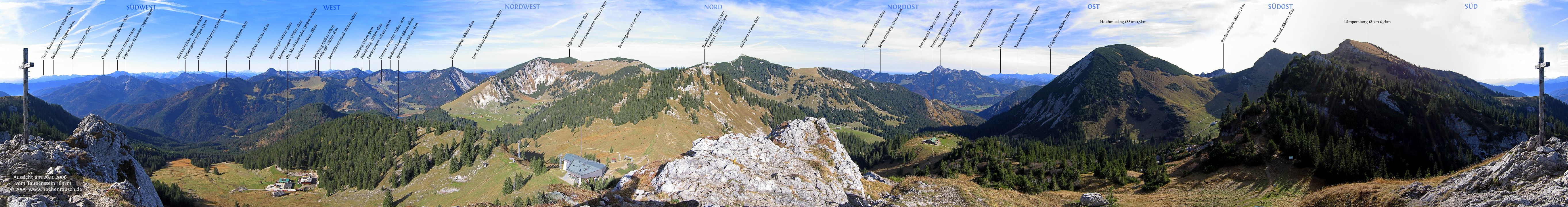
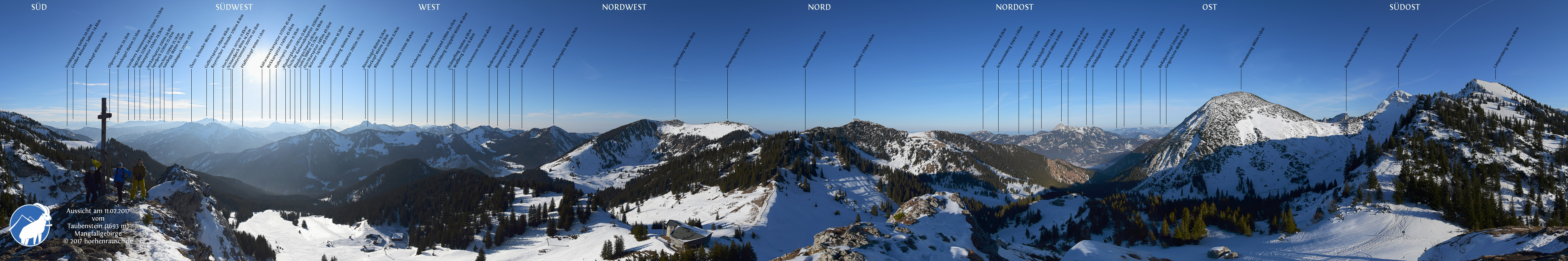
The Taubenstein is often simply tackled in passing during the transition from the Rotwandhaus to the Taubensteinsattel, or climbed as a quick little detour from the Taubensteinbahn mountain station. However, a visit to the Taubenstein is also worthwhile as a hike in its own right. The Taubenstein has particular appeal as a short excursion when time is limited or as an evening jaunt once the cable car has stopped running. From Spitzingsattel, the Taubenstein can be reached via both the Lochgraben and the Schönfeldalm. We combine the two routes into a short circular walk, passing two places to stop for refreshments: the Taubensteinhaus and the Schönfeldhütte. From the rocky summit, there is a magnificent view stretching as far as the Rofan, the Karwendel and the Wetterstein Mountains.
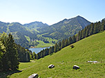
 We leave the car park at the Spitzingsattel via a meadow path heading south-east and make our way towards a grassy slope. We ascend this in a series of switchbacks and reach a shady mountain forest. We continue south-eastwards on a moderate incline along paths that are partly rugged and slippery when wet. Later, the path curves to the right towards the south and we cross marshy terrain via a footbridge. After a left-hand bend, we emerge from the mountain forest and reach a fork in the path. Here we keep to the right (signpost ‘Taubenstein, Rotwand, Taubensteinhaus’) and take the lower path.
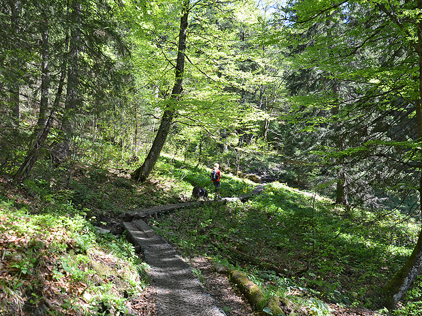 The meadow path leads us gently downhill in a south-easterly direction and, after a right-hand bend, takes us to a patch of woodland. There, the path curves to the left and joins a wide cart track. Walking parallel to the former Lochgraben ski slope, we head south-east through the sparse woodland without gaining much altitude. Shortly afterwards, the trees thin out and we come to a small stream, which we cross. We then hike uphill again on a slightly steeper slope to a cross-path. Here we turn left and immediately right again (signpost ‘Taubenstein, Taubensteinhaus’) and follow a meadow path uphill across the disused ski slope.
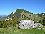
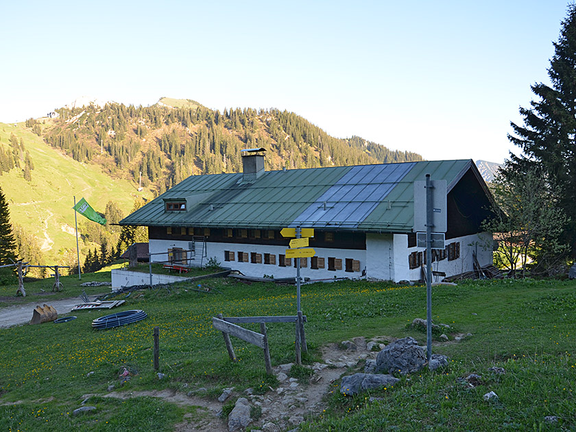
 After two hairpin bends, we reach a wooded area on the left-hand side of the former slope. In the forest, at a junction, we meet the ascent path leading up from the Schönfeldhütte. We keep to the right, leave the mountain forest shortly afterwards and head towards the Taubenstein Saddle. After a walking time of 1¾ hours, we have reached the saddle. Ahead of us, we look out over the Taubensteinhaus towards the Hochmiesing; to the left behind it rises the Wendelstein. To the left, the saddle is bordered by the Rauhkopf; to our right is the Taubensteinbahn mountain station and, behind it, the Taubenstein summit. We turn right and head towards the mountain station.
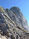
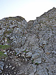
 After a short climb, we cross the terrace of the Taubenstein-Gipfelstüberl and continue behind it along a wide, stony path towards the Taubenstein. After two hairpin bends, the wide path turns into a small stony track. This first leads us towards the summit rocks, then turns left and takes us up over scree to a rock gate. We slip through the narrow gate and walk down in a left-hand bend to a signpost. There we turn right (“Taubenstein 5 min”), walk uphill along a path and then climb a rocky slope, keeping to the right. We then turn left and reach the summit cross of the Taubenstein via a gully secured by wire rope, over bare rock.
 We leave the Taubenstein summit and walk back along the ascent route to the Taubensteinsattel. From there, heading right, we reach the already visible Taubensteinhaus within 5 minutes. At the Taubensteinhaus, we enjoy a beautiful view across the Kleintiefentalalm to the Rotwand. For the return journey to the Spitzingsattel, we descend again via the former ski slope and, at the junction in the forest, choose the route via the Schönfeldhütte. We therefore keep to the right at the junction and shortly afterwards come across a cart track in the forest. We follow this to the right downhill and reach a tarmac cross-path. At the tarmac path, we turn right again and follow it to the Rauhkopfhütte.
 At the Rauhkopfhütte, our route takes a sharp left-hand bend and we follow it uphill to the Schönfeldhütte. Above the Schönfeldhütte, we come to a cross-path and turn left. The meadow path leads us past the Schönfeldhütte and, in a gentle right-hand bend, uphill to a saddle at the foot of the Wilde Fräulein. From the Wiesensattel, we hike downhill in a north-westerly direction and enjoy once again the wonderful view across the Spitzingsee to the Brecherspitz. Finally, we reach the ascent route again, which we follow through the mountain forest down to the Spitzingsattel.
| Elevation | Time | Total | Destination | ||
|---|---|---|---|---|---|
| 1127 m | - 1592 m | + 1:40 | 1:40 | Taubensteinsattel | |
| 1592 m | - 1693 m | + 0:20 | 2:00 | Taubenstein | |
| 1693 m | - 1567 m | + 0:20 | 2:20 | Taubensteinhaus | |
| 1567 m | - 1410 m | + 0:45 | 3:05 | Schönfeldhütte | |
| 1410 m | - 1127 m | + 0:45 | 3:50 | Spitzingsattel | |


