

 Dolomites
Pordoi Pass (Passo di Pordoi, 2239 m) – Pordoi Saddle (Forcella di Pordoi, 2848 m) – Piz Boè (3152 m)
Overall, a challenging mountain hike. The ascent from the Pordoi Pass to the Pordoi Saddle is steep over the top third through scree-covered terrain. The final ascent to the summit involves three short rock sections secured with wire ropes. The second and third rock sections can be bypassed via a path. A sure-footedness and a head for heights are essential for climbing Piz Boe.
Take the Munich–Innsbruck–Brenner motorway to the Klausen exit. After the exit, go straight ahead at the roundabout into the Val Gardena valley and drive via Ortisei, Santa Cristina and Selva up to the Sella Pass. After the Sella Pass, keep left at the next junction and drive up to the Pordoi Pass. Park your car on the right-hand side at the large car park there.
Take the train from Munich via Innsbruck to Franzensfeste and continue on the regional train towards Bruneck to St. Lorenzen. From the station in St. Lorenzen, take bus route 460 to Corvara (for timetable information) and from Corvara take the Dolomiti Bus 472 to the Pordoi Pass.
Using the cable car that runs from the Pordoi Pass up to Sasso Pordoi (2950 m) reduces the ascent time by just under 1½ hours. From the mountain station at Sasso Pordoi, it takes 10 minutes to descend to the Rifugio Forcella Pordoi (2,848 m), where you join the ascent route. On the descent, taking the cable car would save you 1 hour. The return journey from the Pordoi Pass to the mountain station takes 15 minutes and involves a 100-metre climb.
46.48773399, 11.81080699
Anzeige
Piz Boe is the highest point of the Sella Group and is considered the easiest three-thousander in the Dolomites. However, it only holds this title if you take the ascent from the Pordoijoch via the Pordoischarte towards the summit. On this route, you mainly walk on easy terrain. Only on the final ascent to the summit is there some light scrambling to master three rock steps secured with wire ropes. Two of these obstacles can even be bypassed. We therefore set off from the Pordoi Pass and hike towards the imposing south faces of the Sella. The path leads us laboriously up to the Pordoi Saddle via numerous hairpin bends over scree. At the saddle, the scenery changes abruptly and we find ourselves in the midst of the lunar landscape of the Sella massif. At the Rifugio Forcella Pordoi, which offers us the chance to fortify ourselves before the summit push, we look down into the deeply incised Valon del Fos. After the hut, there is a short traverse and a further ascent that takes us to the foot of the summit ridge. After the aforementioned climbing sections secured by wire ropes and steep walking terrain, we finally reach the Rifugio Capanna Piz Fassa on the summit and enjoy the fantastic panorama over refreshments and a snack.
 We leave the large car park at the Pordoi Pass (2239 m), walk back to the road and cross it. A short distance to the right (east) of the valley station of the Sasso Pordoi cable car, we see the Fausto Coppi monument. This is where the signposted ascent route to Piz Boe begins. We take the path, which is partly built with steps at the start, and head towards the south faces of the Sella Group. After just under a quarter of an hour, we come to a grassy hill, which we cross on its left-hand side. After the grassy hump, our path curves to the left and now leads us north-westwards towards Sasso Pordoi. The path becomes rockier as we continue. After a few hairpin bends, the route takes us past a grassy ridge. A little later, we come to a signpost and follow it northwards towards the Pordoi Saddle, which is already visible. We draw closer to the mighty walls of Sasso Pordoi.
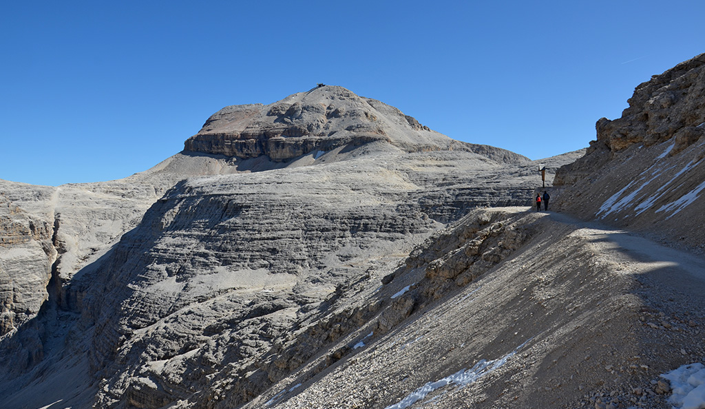
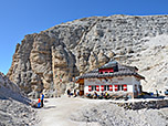
 The terrain becomes increasingly scree-covered and the ascent significantly more arduous. We ascend towards the Pordoi Saddle in a series of hairpin bends. Looking back, we gaze across the Pordoi Pass towards the glaciated Marmolada, whose main peak, Punta Penia, at 3,343 metres marks the highest point in the Dolomites. Just below the saddle, the path becomes significantly steeper and the hairpin bends shorter. After a walk of 1½ hours, we finally reach the Pordoi Saddle (Forcella di Pordoi, 2,848 m) and, with it, the Rifugio Forcella Pordoi situated on the saddle. From the refuge, we now look up for the first time towards the summit of Piz Boe, which will be our next destination. To the left, the view into the Valon del Fos is fascinating. Behind the hut, an antiquated outhouse towers above the valley, its location certainly possessing scenic charm, though it cannot compete with the sanitary facilities of the modern hut.
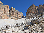
 After a rest, we take the signposted path at the Pordoi Pass towards Capanna Fassa and Piz Boe. This leads us on level ground eastwards, past a wayside shrine. We then traverse the scree slopes of the southern face of the Sella in a gentle up-and-down pattern. Later, our path curves gently to the left and leads us to a junction with a signpost. There we turn right, choosing the path to Capanna Fassa and Piz Boe. Heading roughly south-east, the stony path leads us uphill in switchbacks. After a short climb, the route turns left (north-east) and leads us up to the spacious saddle between Piz Boe and Punta de Joel. At the broad saddle, we head north-east across the flat terrain towards Piz Boe and its summit hut. The path gradually becomes steeper and takes us, via a left and a right bend, to a rocky ledge. Using some wire rope safety lines and steps, we scramble over the rock barrier.
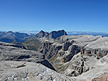
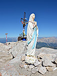
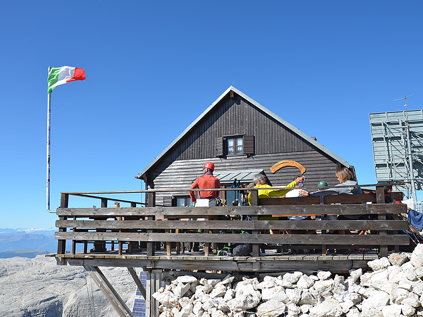 After this easy bit of climbing, the path takes us to a rocky ramp, which is again overcome with a simple scramble. The second short via ferrata can also be bypassed by keeping to the left. However, this route is reserved for those descending, so you should let oncoming traffic pass first here. Shortly afterwards, we reach the third obstacle, which can again be bypassed on the left via a narrow path. The stony path then winds its way uphill in many short hairpin bends, leading us swiftly towards the summit. One and a half hours after leaving the Pordoischarte, we stand at the Rifugio Capanna Piz Fassa and thus at the highest point of Piz Boe (3,152 m), which is also adorned with a small cross and a statue of the Madonna. We enjoy the wonderful panorama of the Dolomites and also gaze towards the three-thousand-metre peaks of the Ortler Group, the Ötztal, Stubai and Zillertal Alps, and the Hohe Tauern.
Same as ascent. Alternatively, from the Rifugio Forcella Pordoi up to Sasso Pordoi (15 minutes and 100 metres of elevation gain) and descent by cable car.
| Elevation | Time | Total | Destination | ||
|---|---|---|---|---|---|
| 2239 m | - 2848 m | + 1:30 | 1:30 | Pordoischarte | |
| 2848 m | - 3152 m | + 1:30 | 3:00 | Piz Boe | |
| 3152 m | - 2848 m | + 1:15 | 4:15 | Pordoischarte | |
| 2848 m | - 2239 m | + 1:15 | 5:30 | Pordoijoch | |


