

 Wetterstein Mountains
Ehrwald, Zugspitzbahn valley station (1,220 m) – Gamskar – Wiener-Neustädter-Hütte (2,213 m) – Stopselzieher – Zugspitze (2,962 m)
The ascent from Ehrwald via the Wiener-Neustädter-Hütte to the start of the Stopselzieher via ferrata is a challenging mountain hike with short exposed traverses and two short climbing sections. The approach through the scree of the Gamskar and Schneekar is quite arduous in places. The Stopselzieher is an easy via ferrata with a few moderately difficult sections (mostly A and A/B). The via ferrata is frequently interrupted by walking sections and short unsecured climbs up to a maximum difficulty grade of 1. In the upper part of the via ferrata there is a lot of loose rock, so wearing a rockfall helmet is advisable. It is recommended that you bring via ferrata equipment. The long ascent requires good physical fitness, sure-footedness and a head for heights.
Rockfall helmet, possibly via ferrata equipment.
Take the Munich–Garmisch motorway; after the motorway ends, continue straight on through Oberau towards Garmisch. After the tunnel, turn right towards Reutte/Fernpass. Drive through Garmisch and Grainau, via Griesen, to Ehrwald. Once you have passed under the railway line in Ehrwald, turn left and, opposite the petrol station, turn left again straight away into Zugspitzstraße. Now follow Zugspitzstraße through Ehrwald (signposted “Zugspitzbahn”) and on to the valley station of the Tiroler Zugspitzbahn. Park your car there.
From Garmisch-Partenkirchen, take the regional train towards Reutte in Tirol to the Ehrwald Zugspitzbahn stop. From the station in Ehrwald, take the summer bus (lines 1 and 2) to the valley station of the Tiroler Zugspitzbahn (for timetable information).
47.42657379, 10.94227544
Anzeige
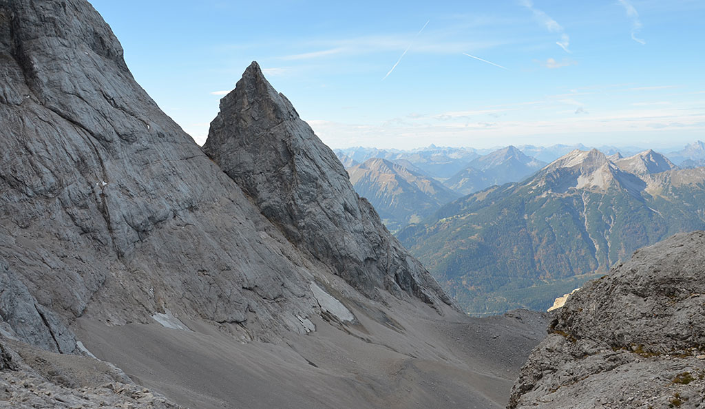
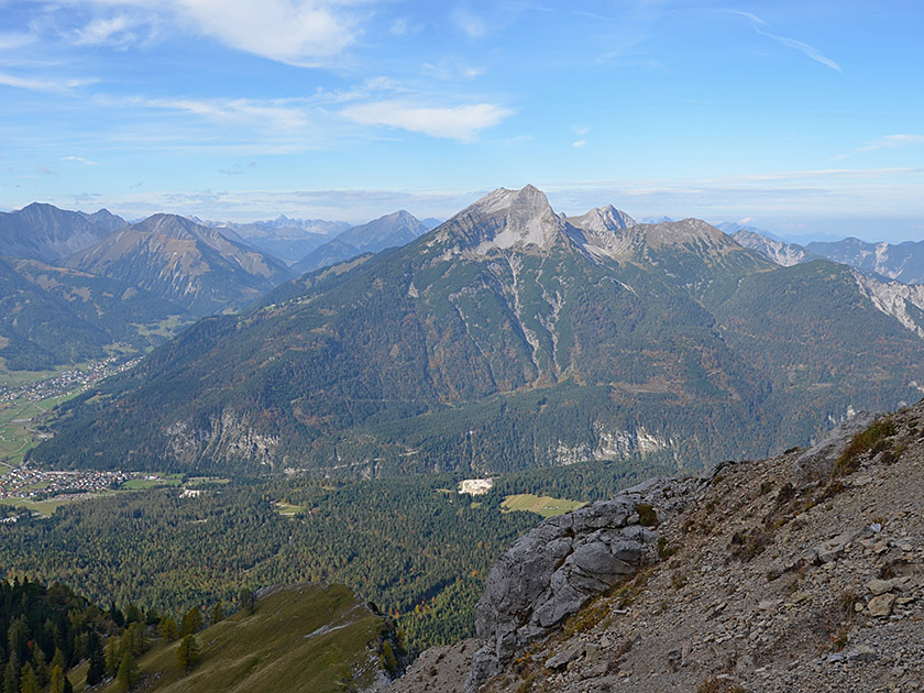
If you avoid using any lifts altogether, the ascent from Ehrwald via the Wiener-Neustädter-Hütte and the Stopselzieher is the shortest and quickest route up to the Zugspitze. Yet even with the quickest ascent route to the Zugspitze summit, what lies ahead is anything but a walk in the park. From the valley station of the Tiroler Zugspitzbahn, you still have to climb 1,750 metres in altitude before you can enjoy the thrill of reaching the summit at Germany’s highest point. Whilst the route itself is not quite as spectacular as the path via the Höllental, it is nevertheless very entertaining and varied. The highlight of the ascent is the easy via ferrata leading from the Schneekar up to the summit ridge. This involves climbing through a natural tunnel known as the ‘Stopselzieher’. After this long and strenuous mountain hike, you can make use of the Zugspitzbahn with a clear conscience and glide gently back down to the starting point in Ehrwald, sparing your joints.
 From the car park, walk past the Zugspitzbahn valley station heading east. Immediately after the valley station, we come to a fork in the path and continue straight ahead (signposted “Wiener-Neustädter-Hütte, Zugspitze”). Shortly afterwards, the path takes us round a building in a right-hand bend. At the back of the building, we keep diagonally to the left and head up to a cross-path. We follow the cross-path a few steps to the right and then reach a junction. Now we turn left (signposted “Zugspitze”) and follow the wide track of the former ski slope uphill in a south-easterly direction. About 20 minutes later, after a gentle right-hand bend, we come to a path that leads off to the left of the track into the mountain pines (no signposting, just red dots).
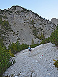
 Here you now have the option of turning left onto the path into the Gamskar. If you wish to avoid the scree-covered path, continue straight ahead and follow the former piste as it curves left into the Gamskar. Both paths meet again after just under 15 minutes. Shortly after the two routes converge, a clear marking with the red letters “W. N.” points the way to the right into the mountain pines. We now follow the former grassy piste again through a mountain pine alley. After a sharp left-hand bend, the grassy track gradually disappears into the scree. We now walk across stony terrain in a north-easterly direction into the Gamskar basin, framed by high walls. The path now winds its way uphill somewhat more steeply and, after a total walking time of 1¼ hours, we reach a watering hole.
 From the watering hole, the path leads us in numerous switchbacks, first through mountain pines and then up a rather arduous climb up a scree slope. Half an hour later, we come across a traverse path below a high rock face. To the left, we can see the former middle station of the cable car. Looking towards the rock face, we turn right and now take the Georg-Jäger-Steig. However, we do not follow the footpath that leads steeply up the scree slope, but instead cross to the right past the scree gully and head slightly downhill into the Gamskar (look out for the red markings!). After the crossing, the path takes us swiftly uphill in a northerly direction via switchbacks and a few steps. After a short, steeper climb, the path turns left (west) and leads us up to a ridge.
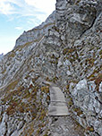
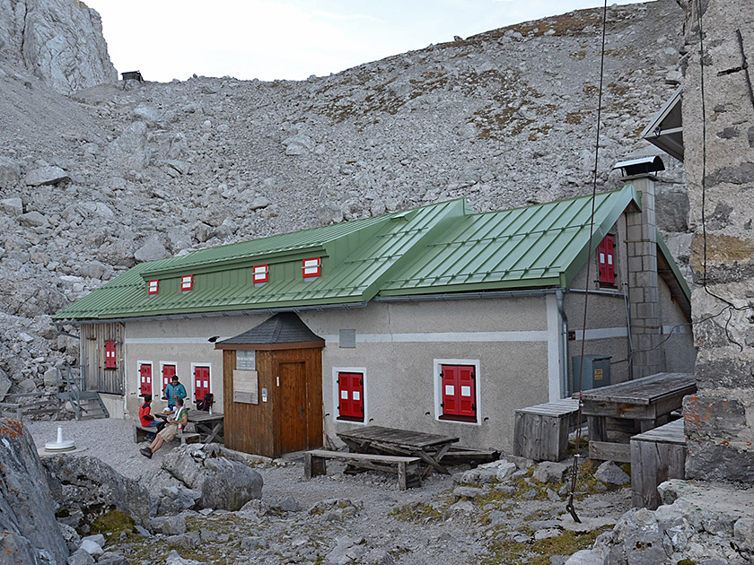 There, the path turns north again and we reach the former support pillar of the old cable car. From there, we head towards the second support pillar of the new Zugspitzbahn. Just before the cable car mast, there is a short rock step secured by wire rope to negotiate. After this short scramble, we pass under the cable car near some avalanche barriers and then traverse into the face via a path that is partially secured and exposed in places. Without gaining much altitude, we walk eastwards and reach an unsecured steep section, which we climb over. This is followed by another traverse and a short, steeper ascent. After the steep step, the markings lead us in a wide right-hand arc over boulders and flat rocks up to the Wiener-Neustädter-Hütte (2,213 m, 2¾ hours from the valley station in Ehrwald).
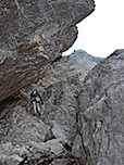
 From the Wiener-Neustädter-Hütte, we cross the scree-covered snow cirque in a south-easterly direction and reach the start of the via ferrata after a good 15 minutes. Via a flat ramp (A) and a few steps (A/B), we reach the natural tunnel of the Stopselzieher. We scramble up through a crevice into the tunnel and exit it shortly afterwards through the low cave opening. We then continue climbing up a crack (A/B) and, after a few metres, come to numerous steps, which we use to climb the wall quickly (A/B). After this long stretch of steps, the terrain levels out and we follow the wire rope mainly on easy terrain up a wide ramp. After a few minutes, the first via ferrata section ends and we follow the markings upwards over mostly solid rock.
 A quarter of an hour later, we come to the next wire rope anchors: These lead us slightly to the right across the ramp (A) to a ridge. We now follow the ridge steeper uphill over stepped and gradually more crumbly terrain (A/B, watch out for falling rocks!). Finally, the via ferrata ends and we leave the ridge, keeping to the left over very scree-covered terrain. The markings guide us across uncomfortably crumbly ground to the old and abandoned cable car station. At the former station, the path turns right and takes us first across a ledge and finally, along some wire rope safety lines, up to the summit ridge. There we meet the hikers who have tackled the ascent of the Zugspitze via the Reintal and the Knorrhütte.
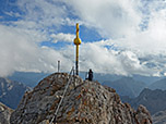
 We are now just under half an hour’s walk from the summit itself. We turn left and follow the ridge north-eastwards, past numerous wire rope safety lines, towards the buildings in the summit area of the Zugspitze. Finally, a path carved into the rock and secured with wire ropes winds its way up to a flight of steps. The staircase leads us up many steps to the Münchner Haus. There we cross the terrace of the Alpine Club hut and then the viewing platform. We walk past the entrance to the cable car on the left and descend at the end of the platform to the foot of the Zugspitze summit. Climbing up a ladder and finally along a wire rope safety line, we scramble over very slippery rock to the summit cross of the Zugspitze.
Same as ascent. Alternatively, take the Tiroler Zugspitzbahn down to the car park (downhill journey 43 euros per person/as of 2026, see information and timetable).
| Elevation | Time | Total | Destination | ||
|---|---|---|---|---|---|
| 1220 m | - 2213 m | + 2:45 | 2:45 | Wiener-Neustädter-Hütte | |
| 2213 m | - 2962 m | + 2:45 | 5:30 | Zugspitze | |
| 2962 m | - 2213 m | + 2:00 | 7:30 | Wiener-Neustädter-Hütte | |
| 2213 m | - 1220 m | + 2:00 | 9:30 | Ehrwald, Talstation Zugspitzbahn | |


