

 Rofan Mountains
Erfurter Hut (1834 m) – Hochiss (2299 m) – Dalfazalm (1693 m) – Erfurter Hut (1834 m)
The direct ascent from the Erfurter Hut past the Gschöllkopf to the Hochiss is a moderately difficult mountain hike leading over stony paths. The connecting ridge between the Streichkopf and the Hochiss is climbed via a steep and rugged flank. Take care in the summit area, as the terrain drops vertically to the north. On the alternative descent via the Dalfazalm, a gully secured with a wire rope must be climbed down at the Streichkopf. The rock is well-stepped but also quite worn. The onward route to the Dalfazalm and the return route are straightforward. Sure-footedness and a head for heights are essential for the described circular route.
Take the Munich–Salzburg motorway to the Holzkirchen exit, then follow the B 318 via Tegernsee and Kreuth over the Achen Pass. Continue via Achenkirch to Maurach. In Maurach, turn right towards the town centre and Pertisau, and after the exit, keep right again (signposted ‘Rofan Cable Car’). After the underpass, park your car in the car park directly at or slightly above the valley station. Alternatively, you can reach the Rofan cable car from the Inn Valley. To do this, leave the Munich–Kufstein–Innsbruck motorway at the Wiesing exit, then head towards Achensee and follow the B 181 up to Maurach. From Maurach, take the Rofan Cable Car up to the Erfurter Hütte (return ticket €29.50, as of 2025).
By train from Munich via Kufstein or from Innsbruck to Jenbach. From Jenbach, continue on bus route 8332 to the Maurach Rofan Cable Car Valley Station stop (for timetable information).
47.42420760, 11.75148726
Anzeige
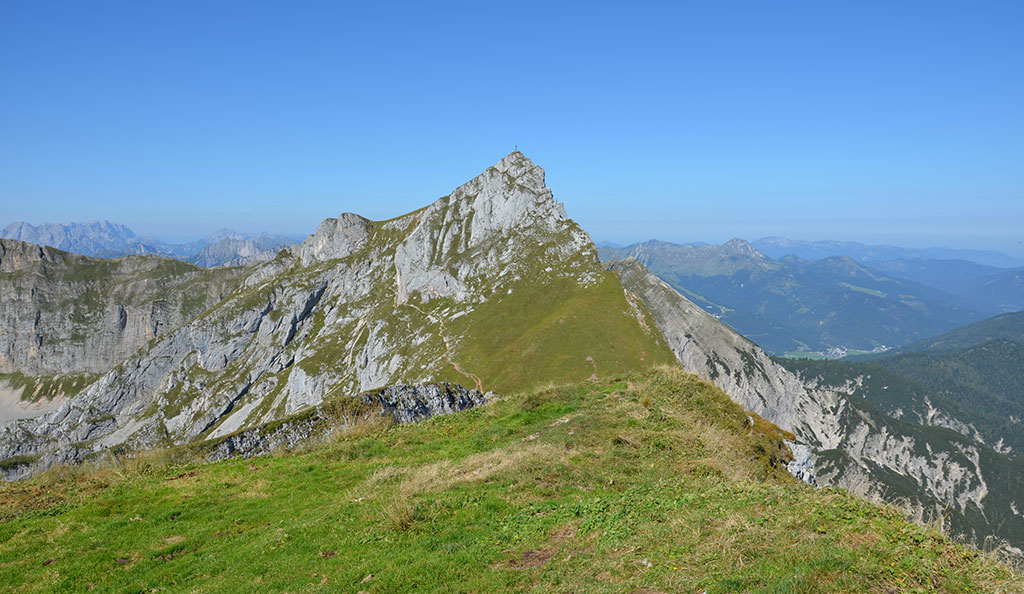
The Hochiss is the highest peak in the Rofan range and the quickest to reach from the Rofan Cable Car mountain station. From there, the direct ascent past the Mauritzalm and the Gschöllkopf takes 1½ hours. This involves walking through a scenic cirque framed by the Dalfazkamm to the west and the Spieljoch on the eastern side. Finally, via steep, rocky terrain, you reach the summit, which offers exceptional views. An alternative route back is the descent via the Dalfazalm. With this option, the crux of the route awaits you at the Streichkopf. Here, you must climb down the Rotes Klamml, a stepped gully secured with a wire rope. After this scrambling section, the path leads past the Steinernes Tor down to the Dalfazalm, which sits majestically above Lake Achensee. At the alpine hut, you’ll have earned a well-deserved refreshment before tackling the return journey and the short climb back up to the Rofan Cable Car mountain station. You should allow just under 4 hours’ walking time for the entire circuit. Further places to stop for refreshments await at the starting point, including the Mauritzalm, the Erfurter Hütte and the Berggasthof Rofan.
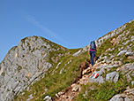
 We leave the Rofan Cable Car mountain station or the Erfurter Hütte (1,834 m) and walk northwards down into a hollow. There we come to a crossroads and continue straight on, with a view of the Mauritzalm and the Gschöllkopf. We pass the Mauritzalm (which can also be reached on foot from Maurach in 2¼ hours; see the tour to the Rofanspitze) and come to a fork in the path immediately after the hut. Here we take the left (upper) path towards Hochiss and Spieljoch. The moderately ascending path leads us past the Gschöllkopf in a gentle right-hand bend. Finally, we reach a rugged slope (secured with wire rope) and then climb up in short switchbacks to a grassy plateau.
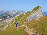
 There we come to a junction and keep slightly to the right (signpost ‘Hochiss, Spieljoch’). We hike north-east across the plateau. Ahead of us, we can already make out our summit destination, the Hochiss. To our left, we are accompanied by views of the Dalfazer Wände. We reach the rocky west face of the Spieljoch and continue at its foot in a north-easterly direction. Later, we leave the junction for the Spieljoch and the Seekarlspitze on our right and continue straight ahead. In a sweeping left-hand bend, our path moves away from the Spieljoch and turns towards the Hochiss. Finally, the path leads us up in short switchbacks to the saddle between the Hochiss and the Spieljoch. At the grassy ridge, we turn left and follow the path westwards.
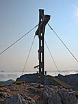
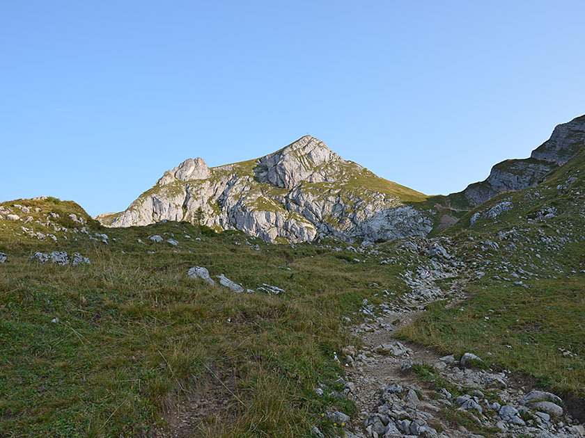
 In a short descent secured by ropes, we pass the start of the Hochiss via ferrata along a rock face. We continue eastwards and, after the rocky outcrop, keep to the right as we climb over steep scree to the ridge between Streichkopf and Hochiss. There we come to a signpost, turn right and follow the ridge upwards, first north-east and later east. Keeping a safe distance from the sheer drop, we reach the summit cross of the Hochiss (2,299 m) 1½ hours after setting off from the mountain station. At the highest point, we enjoy the magnificent panorama, which stretches from the Bavarian Pre-Alps over the Kaiser Mountains and the Berchtesgaden Alps to the Hohe Tauern, the Zillertal Alps and across the Karwendel.
 For the alternative descent via the Dalfazalm, we head back from the summit to the Wiesensattel and turn diagonally to the right there (signpost ‘Dalfazalm, Streichkopfgatterl’). We stay on the ridge for a short while and then traverse past the Streichkopf, keeping to the left. After the traverse, the path leads us up the south-eastern flank of the Streichkopf to another traverse (cable safety line), via which we reach the start of the Rote Klamml. We descend the rocky and steep gully along the cable safety line, using a step aid and stepping over stepped, partly slippery rock, down to a grassy flank. We cross this in a westerly direction and reach the Streichkopfgatterl. At the saddle, we leave the turn-off to the Dalfazer Kamm on our left and follow the path downwards in a south-westerly direction (signpost ‘Dalfazalm, Kotalm’).
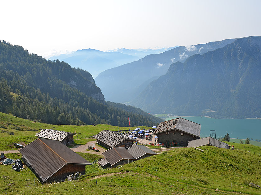 After a steeper descent, our path slowly turns westwards and leads us over a scree slope towards the Steinerne Tor. At the Steinerne Tor (1,955 m), we ignore the turn-off to the Kotalm on the right, keep slightly to the left and continue downhill in a south-westerly direction across the alpine pasture. We pass a cattle trough and, shortly afterwards, our path turns increasingly southwards. Soon we catch sight of Lake Achensee and the Dalfazalm (1,693 m) below us, towards which we eventually hike down a series of hairpin bends (1½ hours from the Hochiss). For the direct return route to the mountain station, we turn left at the Dalfazalm with a view of Lake Achensee (signposted ‘Erfurter Hütte’) and take the wide path that leads gently uphill in an easterly direction.
 From the Dalfazalm, it is also possible to descend directly to the valley station of the Rofan cable car in Maurach via the Durrachalm within 1¾ hours. For the return route to the mountain station, we therefore walk a short distance uphill towards the east. Shortly afterwards, the path curves to the right and leads us south-eastwards at almost the same altitude. Later, the gradient of the path increases slightly and, after a left-hand bend, we pass the turn-off to the Rotspitz. Shortly afterwards, we reach the Durrakreuz. From the wayside shrine, which sits atop a rugged hillock, you can enjoy a beautiful view of Lake Achensee. We then leave the turn-off to the Buchauer Alm on our right and continue eastwards along our path. This leads us through a sparse forest with gentle ups and downs and finally up a steeper climb to the Erfurter Hütte (1,834 m, 1 hour from the Dalfazalm).
Alternatively, you can descend from the Dalfazalm directly to the valley station in Maurach via the Durrachalm in around 1¾ hours.
| Elevation | Time | Total | Destination | ||
|---|---|---|---|---|---|
| 1834 m | - 2299 m | + 1:30 | 1:30 | Hochiss | |
| 2299 m | - 1693 m | + 1:30 | 3:00 | Dalfazalm | |
| 1693 m | - 1834 m | + 1:00 | 4:00 | Erfurter Hütte | |


