


 Chiemgau Alps
Steinbergalm (1000 m) – Bründlingalm (1167 m) – Hochfelln (1674 m)
Easy to moderately difficult mountain hike. The ascent from the Steinbergalm past the midway station of the Hochfellnbahn to the Bründlingalm follows wide forest tracks and roads. Above the Bründlingalm, the route turns into a path that is partly stony and steep in places. A minimum level of sure-footedness is required for the ascent.
Take the Munich–Salzburg motorway to the Siegsdorf exit. After the exit, follow signs for Inzell/Ruhpolding; at the next roundabout, turn right towards Ruhpolding and drive via Eisenärzt to Ruhpolding. At the entrance to Ruhpolding, level with the Aral petrol station, turn right into Maiergschwendter Straße and after 1.1 kilometres, turn right at the fork in the road towards Steinbergalm. Drive up the mountain road to Steinbergalm and park your car there (parking fee €3, as of 2024). The parking fee will be credited if you stop for refreshments at the Steinbergalm.
From Ruhpolding railway station, the climb to the Steinbergalm takes about 1½ hours. If travelling by public transport, the route from the Hochfellnbahn valley station via Kalkofen is much more suitable.
47.76843574, 12.59279966
Anzeige
Without using the cable car, the quickest way to reach the summit of the Hochfelln is from the Steinbergalm. From the Steinbergalm, which is accessible from Ruhpolding via a mountain road, the ascent takes around 2¼ hours. However, you’ll rarely be alone on this extremely popular route. From the Steinbergalm, the path first leads us through the mountain forest on a moderate incline before we enter open alpine pastureland near the Hochfellnbahn’s middle station. The gradient of the path now increases significantly, and shortly afterwards we come to two places to stop for refreshments: the Bachschmiedkaser and the Bründlingalm.
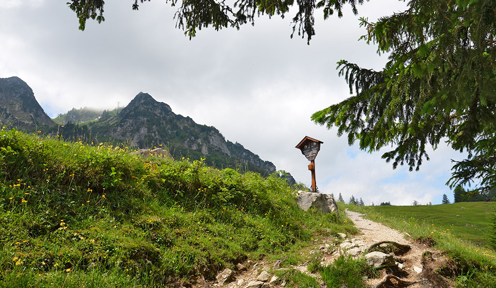
Above the Bründlingalm, it is worth making a detour to a viewpoint adorned with a cross, which offers a magnificent view of Lake Chiemsee. We then ascend via a partly stony path with many hairpin bends towards the Hochfelln summit with the Taborkirche and the Hochfellnhaus. Here, a fantastic panoramic view awaits us over the Chiemgau region, including Lake Chiemsee, the Chiemgau and Berchtesgaden Alps, the Loferer Steinberge and the Kaisergebirge. Those wishing to save a few metres of elevation on the descent can take the Hochfellnbahn down to the middle station and return from there to the Steinbergalm in just over half an hour.
 We walk to the far (western) end of the Steinbergalm car park and, keeping to the left, head up to the forest track, which takes us north-westwards to a pasture gate. We pass through the gate and reach a crossroads at the Hocherbalm. We now turn left and follow the forest track into the mountain forest. The terrain levels out and, after a gentle climb, we subsequently lose a few metres in altitude. Eventually, the path leads us down to a junction, where we turn left. We then walk westwards, following the course of the Schwarzen Ache stream. As soon as we emerge from the mountain forest, we come to a cross-path.
 We now turn left and follow the track as it curves right uphill. We walk a short distance northwards and, in a left-hand bend, pass under the Hochfellnbahn railway line. We then stay on the wide farm track and reach the Bachschmiedkaser (1,130 m) via the winding road. A short distance above the alpine pasture, we pass the Öderkaser (1,161 m) and shortly afterwards reach the Bründlingalm (1,167 m). Here, on the north-eastern side of the Hochfelln, you are spoilt for choice when it comes to stopping for refreshments. At the Bründlingalm, the path turns right (west) and leads us up to the foot of a hill topped with a cross. The small summit can be reached via a short detour.
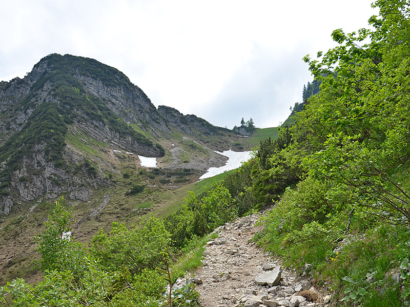 From the small summit cross, we enjoy a magnificent view down to Lake Chiemsee. Back on the path, we turn west and follow the path as it curves left and heads uphill. The wide cart track is now replaced by a narrow path and leads us up to a wooded area. A path with steps leads us steeply uphill through the copse. Afterwards, the trees recede more and more and we reach a basin below the Tröpflwand. In the basin, the path turns left and climbs much more steeply in a south-easterly direction. After a hairpin bend, our path turns west and takes us further uphill in a sweeping right-hand bend.
 Soon afterwards, the wide path ends and a small stony track leads us further uphill, keeping to the left amongst low scrub. The track makes a few short hairpin bends and then leads us southwards towards the saddle between the Strohnkopf and the Hochfelln. Once again, the path leads us uphill in two hairpin bends, finally taking us up to the saddle in a left-hand curve. There, we slip through between two rocks, turn right and walk in a south-westerly direction towards a slope covered in mountain pine. On its flank, the path makes two hairpin bends and we reach a junction. We turn right and follow the winding path up to the top station of the Hochfellnbahn. There we come to a cross-path, turn left and hike up to the Tabor Church, the summit cross and the Hochfellnhaus.
Same as ascent. The descent can be significantly shortened by taking the Hochfelln cable car from the top station to the middle station (€13.50, as of 2026). From the middle station, it is then a 35-minute walk back to the car park at the Steinbergalm.
| Elevation | Time | Total | Destination | ||
|---|---|---|---|---|---|
| 1000 m | - 1167 m | + 0:50 | 0:50 | Bründlingalm | |
| 1167 m | - 1674 m | + 1:25 | 2:15 | Hochfelln | |
| 1674 m | - 1167 m | + 1:10 | 3:25 | Bründlingalm | |
| 1167 m | - 1000 m | + 0:40 | 4:05 | Steinbergalm | |


